- What spatial reference system(s) do you use for your field data, and why?
- Will you change the SRS you use based on what you’ve learned in this module?
1 Like
I’m a student who has not done much work with collecting location coordinates etc. So I don’t know of any spatial reference system etc. This module did however give me insights to watch out for the types of SRS I use in the future when I learn more about field work data collection etc.
1 Like
HI,
I am still at the confused stage of understanding the difference between CRS and SRS. I’m based in New Zealand and use Long-lats for co-ordinate references and use NZGD 2000 New zealand traverse mercator or NZGD 2000 wellington circuit. I use this as it enables me to plot my vector data (Penguin nestboxes and pest traps) on there from csv files.
As of now i was only known about the WGS84 EPSG 4326 CRS which i was using for my field GPS data (Lat - Long coordinate type) apart from this i haven’t explored much in this due to my limited knowledge about the use of GIS. But this module has really gave me a boost in understanding about the basics of CRS/SRS and their uses as per the suitability and the type of field data coordinate.
We use the standard WGS84 as we’re in the UK but in the past I’ve used a vairety of different ones as I was working in Canada, South Africa and Australia. Will need to go and refresh my memory. We also tend to use grid references rather than lat/long coords at work - not entirely sure why so I might try and find out and have a deeper discussion about that too
1 Like
I have been using WGS 84. So far there was no need to use other SRS yet. Also, with my limited knowledge in GIS, I have not explored other SRS. However, this module provides a fresh understanding on how maps are projected and there may come a time that we need to use other SRS.
I can’t say I am a user of GIS yet, but the spatial reference system I seem to encounter most is WGS84. I don’t understand the language of GIS enough to understand the advantages of this system beyond simply repeating what I have read. From this module I anticipate that I’ll be able to experiment with changing SRS to be compatible with whatever data source(s) I am using.
As far as I know, I believe the WGS84 EPSG 4326 CRS will be used in my field GPS data (Lat - Long coordinate type). Apart from WGS84, I haven’t explored much due to my first exploration of the use of GIS. But this module has helped me to differentiate and understands the basic of CRS/SRS and uses in the type of field data coordination.
#neverstoplearning
I haven’t used my own field data for a map yet so I haven’t used a specific SRS over another before. However now that I know the difference between GPS co-ordinates styles I will be able to change the Geometry CRS accordingly by either applying what Ive learnt on this course or using the same system as my colleagues or the same system as the complementary data I use, has used
I have not collected my own field data as of yet; however, I know that other students in my lab use latitude and longitude when logging their co-ordinates in the field (WGS84 EPSG 4326 CRS). Perhaps I would do things a little differently if I were to log this data myself. I will be sure to use a CRS that is relevant to the scale at which I am working (regional).
I am new to GIS, so I do not have my own data yet. But Hungary has a few SRS such as HD72 / EOV or GCS S42 Hungary. I think I do not have a choice in the SRS, while I will have to use the SRS of the provided maps.
As someone who is new to GIS, I do not know of other SRS besides the ones used in the lesson.
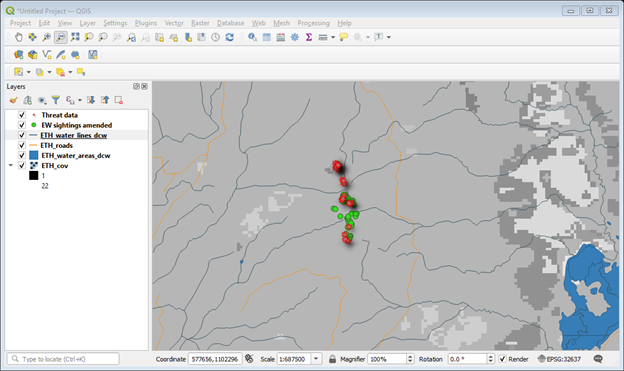
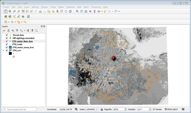
Hello there? As per the instruction in the module, I’ve tried to add my own geospatial datasets to QGIS project for the first time as I’m new to GIS. First I tried to grasp the concepts both from this module and from other online sources. My organization Ethiopian Wolf Conservation Programme /EWCP/ has been collecting wolf sightings, threats, camera trap locations, elevations, etc data for years & compiled them on spreadsheet. So, I picked the wolf sightings and threats datasets in the excel format and converted them to *.csv/comma delimited files/. These data were collected from the field based on projected coordinate system since we usually use GPS equipment to collect the UTM_E & UTM_N readings of the locations of our targeted specie- the wolf- and other related data.
The spatial reference system/SRS/ - in GQIS terms CRS- I used ( for this case) and I will use in future , I guess, is the Universal Transpose Mercator WGS 84/ UTM zone 37 EPSG:32637. Why? because I found this SRS/CRS very appropriate for extent of my field dataset & for Geographic coordinate of Ethiopia among lists of several feasible SRSs I accessed online. Besides, I succeeded in making the map of my own for the wolf sightings & threats datasets. I even downloaded the Land cover, roads, water lines and water areas of Ethiopia and added them to the QGIS project I created as Layers. This really is a joy for me as this is my first try.
Yes, now I can change the SRS I’m using to other SRS/CRS based on the lesson I’ve learned in this module. By the way, here below I posted too the QGIS project screenshots I created for my own datasets. Any opinion or correction you may forward to me, please don’t hesitate to do so. You are most welcome.
3 Likes
I am in New Zealand use the standard WGS84 system. However it can be hard to get accurate GPS points here because of poor satellite coverage. I might be looking into some of these other systems to see if if anything might be better!
I collect lat/long data on a handheld GPS and have only used the (Coordinate Reference System) CRS, WGS84- a Web Mercator Map Projection. Since I work in the Philippines and Indonesia, I think the type of Map Projection would not make such a big difference because the two countries are close to the equator.
Right now, my spatial datasets are just the GPS coordinates but I would like to incorporate seagrass and mangrove layers created by collaborators and I need to ask them what kind of SRS those used since they were created from a mixture of remote sensing and hand-drawn ground truthing data (drawn on Google Earth Engine). Based on what I learned in this module, I need to ask my collaborators what SRS they used to be able to integrate the different layers under the same Project.
I am using WGS84 EPSG:4326 for my field data because we are using longitude/latitude in decimal points as our standardization.
I have learnt new lesson on SRS today, but I will not change it because we have been using long/lad as our standardized method and most of our collaborators and research papers do not apply EPSG:3410 too.
Thank you for introducing map projection in this module!
1 Like
Actually I was not really aware anymore about all the different avaiable SRS systems as it has been about 8 years ago working with GIS. I just checked the SRS system of my data and I am using WGS84, which if I read correctly is the most common SRS to be used. As the company I work for is dealing with inserting observations from WrnPro into QGIS and the SRS seem to be well with this, I do not see a reason of changing, although I am happy to have learned the different available options. Maybe I will be in need of it in the future.
I don’t have any field data myself yet as I am completely new to this but reading the replies here I think I’d be starting with the standard WGS84 SRS.
Am I right in thinking that when you take field data you will use one specific kind of SRS and so it is necessary to use the same SRS when you add it to QGIS?
I have only been using WGS84 EPSG 4326 CRS, I was unware of the other ways to go about this.
For my Final year project I used latitude and longitude type with the help of my senior and upcoming thesis I will be using WGS84 EPSG 4326 CRS. Besides, WGS84, I haven`t try any since I am just a beginner and I think in my research region CRS will be relevant. After only learning module 3, I got to know the differences and also understand CRS and SRS. Plus, module 3 taught me the uses in the type of field data coordination.