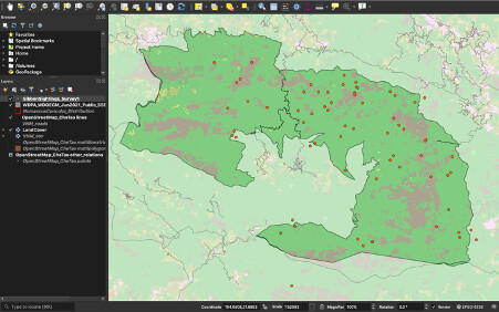
It was a bit challenging to finish this module because I took too much time trying to understand the difference between Continous and Thematic raster. I hope I have I have improved.
Andrew
Andrew
Again, this was a good refresher. I like how concise your instructions are. I can’t wait to try these out with my own data sets.
Although, i am not sure i did the right thing. I am noticing very different screenshots in the Discussions LOL.
My screenshot looks like yours too! I don’t think its wrong… If we hid the VNM_cov layer, it might look more ‘correct’. 
On this module 2 I learn more different between raster and vector data and to add it on the project.
I would like to know why your project shows places
Thats a wonderful work
I was also confused at first i downloaded the one with Afghanistan and the results were default and then i re-read the instructions and changed it to Vietnam that was required

It was interesting to look at the different resolutions of the different datasets. Both the VNM road map and land cover datasets were not very useful at such a fine scale and neither was the IUCN distribution polygons – so I excluded them from the final map and instead used the outline of the park, the OpenStreetMap roads and the LandCover dataset, together with the survey data. What I took away from this, is that it is important that the resolution of the raster file is suitable for the scale of the area on which you are working.
Was initially quite confusing but it’s slowly starting to come together. It is becoming easier to navigate through the software and to add and order the different layers. I think I’m beginning to understand the difference between vector and raster.
I like the way you have been able to separate the 2 layers (orange from black & white). Really helps with the visual interpretation.
Hi emmamay,
I like all the different colours on your map! It makes it a lot easier to see the different objects.
I hope I can help answer your question about the fine-scale vector data. Because there are so many layers on the map it is a bit confusing to compare layers directly, so to look at the difference, for example, between the road dataset that was downloaded DivaGIS (course-grain dataset) and the road dataset that was downloaded from OpenStreetMap (fine-grain dataset), I unticked the other layers in the layer panel so that they were not visible on the map and then changed the colour of the two datasets. It also helps to have something to reference the detail of the datasets, like the outline of the nature reserve. If you look at the OpenStreetMap dataset - it is a much more detailed version of the roads in the area than the DivaGIS data. So if, for instance, you wanted to look at whether any gibbons were surveyed near a road in the nature reserve - it would be more useful to look at the fine-scale data which actually shows the roads in the nature reserve vs the course-grain data which probably just shows main roads (ie the roads which are in the nature reserve might be to small to be captured in that dataset).
Hi, anna
May I please ask how you got assignment 2? I can no longer see the homepage where the assignments are nor have any idea of how to get it. Or do you need a link to get access to it?
Thanks and regards,
Athenkosi
Hi, Anele
May I please ask how you got assignment 2? Did you get a link that leads there or ? I’m a bit confused because I can’t see it nor see the homepage with the tabs where the assignments are listed.
Thanks
Regards,
Athenkosi
Hi All,
I’m so confused right now. I feel like I have absolutely no idea of what exactly was required in this assignment and I don’t understand any of the terms:(. In a nutshell; I didn’t get the crux of the exercise and would appreciate any assistance.
Thank you!
This module took me a while to complete, I was having problems with downloading and uploading the WDPA file, I encountered many errors but after referring to discussions between my fellow students I was able to resolve it.
The instructions are clear and easy to follow. This module has helped to understand the differences between the vector and raster layers. I like the quiz sections.
thank you so much for the advice